Winter Storm CO Warning

Occasionally we will share severe weather information consequential to public health, public safety and EMS response. Below is a CT DPH Press Release addressing the dangers of Carbon Monoxide Poisoning.


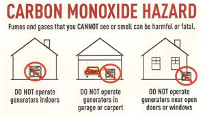
HARTFORD – With growing confidence that Connecticut will be impacted by a major winter storm on Tuesday, the Connecticut Department of Public Health (DPH) warns residents of the dangers of carbon monoxide (CO) and urges them to take steps to prevent deadly CO poisoning. In anticipation of power outages, DPH is very concerned about improper use of portable generators and other sources of heat, which could lead to CO poisoning. When power goes out many people run portable generators inside or close to the home, or use charcoal grills inside the home. Generators should be placed at least 20 feet from the house and never inside the house, on a porch, basement, garage or shed. Charcoal grills should never be used indoors.
CO is an invisible, odorless gas that can be fatal. Breathing in excessive amounts of CO can cause loss of consciousness and death. The symptoms of CO poisoning can mimic those of the flu, including headache, fatigue, dizziness, weakness, nausea, vomiting, chest pain, confusion, or loss of consciousness. People who are sleeping or unconscious can die from CO poisoning before they exhibit any symptoms. DPH warns that anyone exhibiting these symptoms should leave the house immediately and call 911 and the Connecticut Poison Control Center at 1-800-222-1222 from another location.
Improper use of portable generators have caused more than half of CO poisonings in Connecticut, according to DPH. DPH offers the following safety tips to prevent CO poisoning:

• Never use portable generators or other gasoline-powered equipment (including tools) indoors or in the garage, basement, shed or other enclosed spaces. Even if the garage or shed doors are open, CO gas can still build up to dangerous levels within minutes.
• Place portable generators at least 20-25 feet from your home. There have been instances where exhaust containing CO gas has been blown back into the house and poisoned occupants when outdoor portable generators were close to the house.
• Opening windows and doors, and operating fans is NOT sufficient to prevent buildup of CO in a home.
• Use charcoal and gas grills or camping stoves outdoors only.
• Make sure exhaust vents for your furnace and gas appliances (dyers, stoves) are free of snow. Exhaust vents blocked by snow can cause combustion gases to back up into the home.
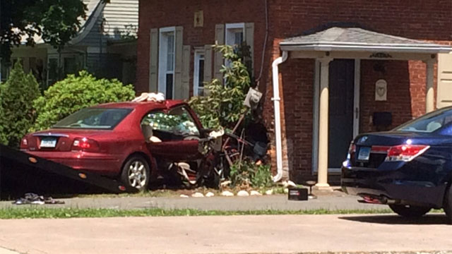
• After a snow storm, make sure your car’s exhaust pipe is clear. A clogged exhaust pipe could lead to carbon monoxide buildup in your vehicle. Fatalities have resulted from people trying warm themselves in their car without clearing snow away from exhaust pipe due build-up of CO gas in car.
DPH developed a video, Carbon Monoxide: The Silent Killer, to help raise awareness of the dangers of CO and how to prevent poisoning. It is available online in English and Spanish by clicking on the following link: https://www.youtube.com/watch?v=Pe-8QcFJ1ME .


Winter Storm Stella

Occasionally we will share severe weather information consequential to public health, public safety and EMS response. Below is a warning issued by CT DESPP-EMHS.


BLIZZARD WARNINGS ISSUED FOR SOUTHERN CONNECTICUT…
WINTER STORM WARNINGS ISSUED FOR NORTHERN CONNECTICUT…

Tuesday Morning: Snow beginning between 4:00 – 6:00 AM and becoming
heavy by 9:00 AM. Blizzard conditions are expected after 9:00 AM with
extremely heavy snow (3” – 4” per hour), Northeast winds gusting to 60
MPH at times with near zero visibilities. A crippling impact on all travel is
expected. Minor coastal flooding is also possible at noontime.
Tuesday Afternoon: Blizzard conditions continue thru the afternoon with 3”
– 4” per hour snowfall rates and winds gusting to 60 MPH at times.
Conditions are expected to start to improve by 4:00 PM as the snow tapers
down to moderate levels and then to light levels by 7:00 PM.
Tuesday Evening: The light snow may continue for a few hours and end
completely by 11:00 PM. However the strong winds may continue into
Tuesday night gusting to 30 MPH at times causing a lot of blowing and
drifting of snow.
Total snowfall: of 18 – 28 inches is currently expected across Western and
Central CT with lesser amounts near the southeast coast of 10” – 15”. The
Department of Emergency Services and Public Protection Division of
Emergency Services and Public Protection will continue to closely monitor
this dangerous storm. Another update will be sent out this afternoon at 2:00
PM once the new model runs are in.

Winter Storm Tracking

Occasionally we will share severe weather information consequential to public health, public safety and EMS response. Below is a warning issued by CT DESPP-EMHS.


WINTER STORM WARNINGS ARE NOW IN EFFECT FOR THE ENTIRE STATE…

BLIZZARD WARNINGS HAVE BEEN ISSUED FOR LONG ISLAND…

HEAVY SNOWSTORM UNDERWAY ACROSS SOUTHERN NEW ENGLAND…

STATUS OF THE STATE EMERGENCY OPERATIONS CENTER – ACTIVATED

At 7:45 AM: Moderate to heavy snow was falling across the state. Roads are quickly

becoming snow covered with lowering visibilities. Temperatures are currently in the

upper 20’s and low 30’s across the state. Northeast winds are sustained at 10 – 15

MPH, gusting to 30 MPH at times along the coast.

Rest of This Morning: Snow, heavy at times with near blizzard conditions and

snowfall rates up to 3” per hour. A major impact on travel is expected with several

inches of snow on most roads. Very slick driving conditions are expected with low

visibilities down to ¼ mile at times. Northeast winds will increase to 15 – 25 MPH,

gusting to 35 MPH at times along the coast. Temperatures will continue to fall into

the upper 20’s by noon.

This Afternoon: Snow beginning to taper off during the early afternoon and ending by

5:00 PM. Blowing and drifting of the snow is expected with north winds gusting to 20

– 35 MPH. The impact on the afternoon rush hour is expected to be at the high end of

moderate with some snow cover remaining on most roads and temperatures in the

upper 20’s.

Total accumulations are currently forecast to range from 12″ – 16″ statewide with

isolated higher amounts especially in eastern CT. The snow is expected to be dryer in

northern and central CT and somewhat wetter along the southeast coast. No icing or

significant coastal flooding is expected with this storm. The overall impact of this

event is expected to be major.

The next update will be sent out by the Department of Emergency Services and Public

Protection Division of Emergency Management and Homeland Security at 10:00 AM.


Winter Storm “Chris” Update

Occasionally we will share severe weather information consequential to public health, public safety and EMS response. Below is a warning issued by CT DESPP-EMHS.

WINTER STORM WARNINGS ISSUED FOR THE ENTIRE STATE…
HEAVY SNOWSTORM EXPECTED ON THURSDAY…
STATUS OF THE STATE EMERGENCY OPERATIONS CENTER – MONITORING

As colder air moves into our area tonight a low pressure system is forecast to form along the cold front in Virginia. This low is forecast to move quickly to the Northeast as the storm intensifies Thursday morning off the Del-Mar-Va Peninsula. The storm is forecast to generate a large area of moderate to heavy snow which will impact southern and central New England on Thursday. The following forecast is based on a blend of the GFS and NAM models and currently has a good confidence level:

Tonight: Becoming cloudy with temperatures dropping into the mid 30’s. Snow is expected to move into the state between 5:00 – 7:00 AM Thursday morning. The snow is expected to become moderate within 2 hours of starting. Temperatures continuing to fall into the low 30’s by daybreak.

Thursday Morning Rush Hour: Moderate snow becoming heavy at times with 2+ inches of snow on roads and snowfall rates of 1″ – 2″ inches per hour by 9:00 AM. The impact on the morning rush hour is expected to start as moderate and become major by the end of the rush hour. Very slick driving conditions are expected with low visibilities down to (1/4) mile at times. The snow is expected to continue heavy at times thru the morning with temperatures continuing to fall into the upper 20’s by noon.

Thursday Afternoon: Snow tapering off during the early afternoon and ending by 4:00 PM. Some blowing and drifting of the snow is expected with north winds increasing to 20 – 30 MPH. The impact on the afternoon rush hour is expected to be moderate with some snow cover remaining on most roads and temperatures in the upper 20’s.

Total accumulations are currently forecast to range from 8″ – 14″ statewide with isolated higher amounts. The snow is expected to be dryer in northern and central CT and somewhat wetter in southern CT. No icing or significant coastal flooding is expected with this storm. The overall impact of this event is expected to be moderate to major.

Updated 2-7-17 at 430PM

Aetna Appears in Local News!


Yesterday evening long time Paramedic and Operations Supervisor Matt Martinelli represented Aetna Ambulance Service Inc. on Fox 61 news. In the interview, Martinelli provides insight on the CT “Move Over” law, and offers a few simple, yet important suggestions to the public. “It seems everyone is in a hurry to get somewhere,” he said. “We just would like to be able to get to the scene in a safe manner so we can provide proper care for a patient.

The article, posted by reporter Jim Altman, and interview can be found in its entirety by clicking the link below!


Emergency responders say drivers aren’t paying enough attention to the “Move Over” Law


Severe Weather Potential for Friday into Friday Night

Occasionally we will share severe weather information consequential to public health, public safety and EMS response.

What we know:

  • Scattered strong to severe thunderstorms may develop after 4 pm Friday afternoon and last to at least 11 pm.
  • Western and Northern Massachusetts as well as Northern CT have the best potential to see strong to severe thunderstorms.
  • Cannot rule out strong storms across RI and Eastern MA during the overnight hours on Friday into early Saturday morning.
  • Main threats within these storms will be damaging winds, hail, and heavy downpours which could lead to localized minor street flooding.
  • An a isolated tornado cannot be ruled out.

What we don’t know:

  • Will Friday morning showers and/or cloud cover limit severe weather potential
  • The coverage of thunderstorms (scattered vs widespread event).
  • If storms will weaken or strengthen as they move eastward into RI and Eastern MA Friday evening into Friday night.

Heat issues Friday & Saturday:

  • Heat and humidity will return beginning Friday and last into the weekend.
  • Temperatures will warm into the low to mid 90s on both Friday and Saturday.
  • Heat Indices could reach the mid 90s on Friday and low 90s on Saturday.
  • Sunday will also be warm with temps in the low 90s.

NEWS ALERT – Aetna Responds to I-91 Exit 26 for Motor Vehicle Accident

Photo credit: CT State Police Twitter feed

Photo credit: CT State Police Twitter feed

For Immediate Release:

ORIGINAL ALERT — Aetna Ambulance is responding to a motor vehicle accident on I-91 North at exit 24 in Wethersfield. Four ambulances are enroute as is an Operations Supervisor for coordination. Reported as six patients, two possibly critically injured at this time. Time of call 1551.

UPDATE – Two patients transported to Hartford Hospital. Four to Saint Francis Hospital, two of which were receiving advanced life support care as of 1622.

FINAL – Six total patients transported as below. No patients remain to be transported at this time.

###

External Winter Storm Update from DESPP: January 2016

DESPP Facts and Figures Jan 2016 StormOccasionally we will share severe weather information consequential to public health, public safety and EMS response.

SOURCE: CT DESPP-EMHS

Click here for full DESPP Report and Map: DESPP External Winter Storm Update 1-22-16 at 115 PM

WINTER STORM WATCHES ISSUED FOR SOUTHERN CT…

LATEST COMPUTER MODELS TRENDING A LITTLE NORTH AGAIN WITH A VERY SHARP NORTHERN EDGE TO THE SNOWFALL OVER CONNECTICUT…

The last model runs of the GFS, NAM and EURO model forecasts are in good agreement on the track however they are still not in good agreement on the amount of snowfall for Connecticut.  The NAM has more than twice the snowfall of either the EURO or GFS.  All three models are still showing a very narrow snowfall cutoff across Connecticut meaning that any slight change in the track will result in a very significant change in snowfall. 

The following forecast is based on a blend of all three models:  Light snow is forecast to spread from south to north across the state tomorrow morning between 6:00 – 10:00 AM.  The snow is forecast light to moderate in northern CT and moderate to heavy at times along the coast by late Saturday afternoon.  The snow is forecast to continue Saturday evening and begin tapering down around midnight.  The snow is forecast to end before dawn on Sunday.  The snow is forecast to be fairly dry and powdery.  The snow will be accompanied by strong Northeast winds gusting to 35 – 45 MPH at times.  Cold temperatures in the upper 20’s are also expected. 

Total snowfall predictions at this time range from 2” – 3” in northern CT, 3” – 6” in central CT and 6” – 10” along the coast.  Note: Very heavy snow with blizzard conditions are expected just to our south over Long Island and New York City.

Current Forecasted Impacts:

Travel Impact:   Saturday AM                  Saturday PM                 Sunday AM                   

                                 Minor                              Moderate                       Minor

Coastal Flooding:   Saturday AM                  Saturday PM                 Sunday AM

                                  Minor                              Moderate                       Minor

Overall Impact:   Minor to Moderate

Forecast Confidence:   Good Confidence for Track / Fair Confidence for Snowfall


State is Monitoring Forecast for Hurricane Joaquin

Hurricane Jaoquin 2015 NOAAGOV. MALLOY SAYS STATE IS MONITORING FORECAST FOR HURRICANE JOAQUIN, ADVISES RESIDENTS TO BE PREPARED FOR POSSIBLE SEVERE WEATHER

(HARTFORD, CT) – Governor Dannel P. Malloy today said that his office and state emergency management officials are closely monitoring the activity of Hurricane Joaquin, which is currently in the Atlantic Ocean, and is advising Connecticut residents to closely follow weather reports and prepare for the possibility of its arrival in the region over the next five days.

“We are monitoring the storm closely, and our state emergency management officials have been in regular contact with the national weather service.  While there are many variables with this storm, we are paying close attention to its track,” Governor Malloy said.  “Just as the state and its agencies are monitoring the weather and preparing appropriately, residents should do the same and closely watch forecasts over the next few days.”

Officials with the Connecticut Department of Emergency Services and Public Protection are prepared to coordinate any potential state response and are participating in ongoing National Weather Service conference calls to receive the latest information on the storm’s track.

Aetna Responds: Car crashes into Wethersfield home; Portion of Route 3 in Wethersfield closed

Credit: WFSB

Credit: WFSB

WETHERSFIELD, CT (WFSB) – A portion of Route 3 in Wethersfield was closed after a motor vehicle crashed into a home on Wednesday afternoon, police said.

The crash was reported in the area of Maple and Prospect streets around 12:30 p.m.

Three paramedic ambulances were sent to the scene, according to Aetna Ambulance Service officials. At least two people, an elderly couple, were rushed to Hartford Hospital. Their conditions were not  released by police.

Police said the vehicle crashed into a power meter before hitting the house. Power was then cut to house before the couple was removed from the vehicle.

It is unclear how long Route 3 will be closed. Read the complete story here…

Winter Storm 2015 — DESPP Update

NWS Map 3UPDATE from the Department of Emergency Services and Public Protection:

At 4:45 AM the radar continues to show bands of Moderate snow sweeping from the south east to the west.

Temperatures are mostly in the teens with some sites along the coast in the low 20’s.

Winds out of the north east are gusting to near 40 MPH.

The most recent snow fall reports of 2 to (almost) 11 inches verifies the presence of the more moderate bands of snowfall in the eastern and central portions of the state.

  • Marlborough – 10.8
  • Manchester – 7.5
  • Coventry – 6.5
  • Thompson – 8.2

Three-quarter to one-quarter mile visibilities also verify the moderate snowfall.

Some drifting has been reported.

The total snowfall forecast may need to be adjusted downward.  One to two foot snowfall totals are still possible with this storm – particularly for the eastern half of the state.  The western side of the state will probably see snowfall totals between 3 and 12 inches.

Gov. Malloy: Take Necessary Precautions for Possible Blizzard Conditions

NWS MapBlizzard Warning Issued for Entire State, Coastal Flood Watch Also in Effect for Entire Shoreline

(HARTFORD, CT) – With the latest forecast calling for blizzard conditions across parts of the state, Governor Dannel P. Malloy is asking residents to be prepared and take the necessary precautions for a significant snowstorm that will impact the state Monday evening through Tuesday.

“Although storms can be unpredictable, this storm has the potential to have a significant impact on the state and we need to be prepared,” Governor Malloy said. “Just as the state is monitoring and preparing, the public should do the same.”

“The Division of Emergency Management and Homeland Security (DEMHS) is monitoring this storm very closely and is prepared to coordinate any potential state response,” Department of Emergency Services and Public Protection Commissioner Dora B. Schriro said.

DEMHS is also participating in National Weather Service conference calls to get the latest information on the storms track and is sending out regular updates to all municipalities and tribal nations.

The Connecticut Department of Transportation will have its entire fleet of snow plows, including 12 loader-mounted snow blowers, prepared to deploy.  The residual road treatment from the previous weekend storm will help in the efforts to pretreat the road

Governor Malloy will be providing the state with additional updates as conditions warrant.

In order to be prepared for any type of emergency situation, the Governor encourages residents to have an emergency supply kit and follow some basic preparedness tips.

   Additional preparedness tips:

  •     In the event emergency travel is necessary, fill up your car with gas, check oil and windshield fluid levels
  •     Sign up for emergency alerts at www.ctalert.gov
  •     And always, check on your neighbor

For additional info on winter weather preparedness go to www.ct.gov/demhs or www.redcross.org.

Aetna’s Jennifer Pasquale and Michael Glazier Receive ‘Unit Citation’

ROCKY HILL — On November 14, 2014 Aetna’s Jennifer Pasquale and Michael Glazier who were recently mentioned for excellent care in service in another blog post, received a Unit Citation from the Rocky Hill Fire Department.

The recognition stems from a September 24, 2014 response in Rocky Hill where the two witnessed a significant head-on motor vehicle crash on the Silas Deane Highway. Their quick action and excellence in clinical care were significant to the patient’s outcome.

Emergency of Hunger food drive kicks off this weekend


POSTED 5:28 PM, NOVEMBER 13, 2014, BY SAMANTHA SCHOENFELD AND MIKE KRAFCIK, UPDATED AT 06:53PM, NOVEMBER 13, 2014 at Fox CT

Article and video appears on Fox CT

VERNON– Food drives are now kicking off for the holiday season, and this year there’s additional need for help in Connecticut cities and towns.

Many who oversee food drives in suburban towns and more affluent parts of the state say the need for food assistance is continuing to increase.

In Vernon Thursday afternoon, a kick-off ceremony was held for the sixth annual Emergency of Hunger Food Drive. Fire officials, police, EMS, hospital staff, Rotary and others are participating to help make a difference.

Over the last five seasons the drive has garnered 147,000 food and personal care items, 4,710 turkeys and more than $96,000 in cash, checks and gift cards.

Last year, fire, police and first responders personally helped to collect 25,000 food items and more than $10,000 in cash and gift cards for many suburban families in need.

Read the full article here…