Extreme Heat Warning

Occasionally we will share severe weather information consequential to public health, public safety and EMS response. Below is a warning issued by the National Weather Service.

EXCESSIVE HEAT WARNING REMAINS IN EFFECT FROM 10 AM THIS

MORNING TO 9 PM EDT WEDNESDAY…

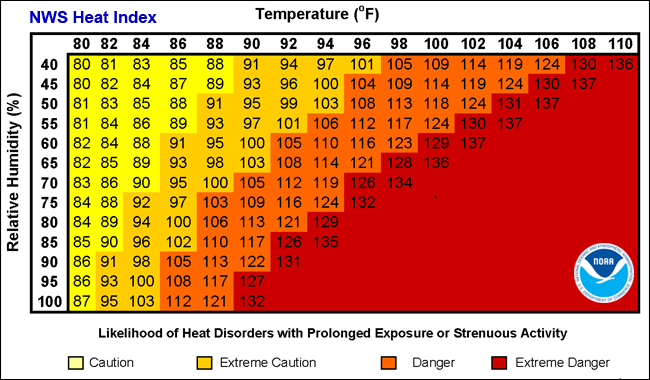
* HEAT INDEX VALUES…100 to 105 degrees.

* TIMING…Today and Wednesday.

* IMPACTS…The heat and humidity may cause heat stress during

outdoor exertion or extended exposure.

* LOCATION…Parts of the Connecticut River Valley and most of

eastern Massachusetts, especially in urban areas.

PRECAUTIONARY/PREPAREDNESS ACTIONS…

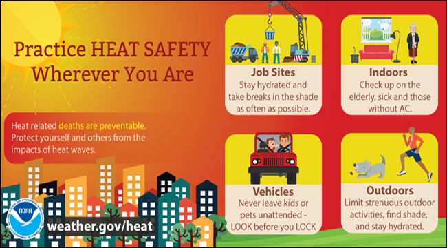
Take extra precautions, if you work or spend time outside. When

possible, reschedule strenuous activities to early morning or

evening. Know the signs and symptoms of heat exhaustion and heat

stroke. Wear light weight and loose fitting clothing when

possible and drink plenty of water.

To reduce risk during outdoor work, the occupational safety and

health administration recommends scheduling frequent rest breaks

in shaded or air conditioned environments. Anyone overcome by

heat should be moved to a cool and shaded location. Heat stroke

is an emergency, call 9 1 1.

Young children and pets should never be left unattended in

vehicles under any circumstances. This is especially true during

warm or hot weather when car interiors can reach lethal

temperatures in a matter of minutes.

Severe Weather Potential for Friday into Friday Night

Occasionally we will share severe weather information consequential to public health, public safety and EMS response.

What we know:

  • Scattered strong to severe thunderstorms may develop after 4 pm Friday afternoon and last to at least 11 pm.
  • Western and Northern Massachusetts as well as Northern CT have the best potential to see strong to severe thunderstorms.
  • Cannot rule out strong storms across RI and Eastern MA during the overnight hours on Friday into early Saturday morning.
  • Main threats within these storms will be damaging winds, hail, and heavy downpours which could lead to localized minor street flooding.
  • An a isolated tornado cannot be ruled out.

What we don’t know:

  • Will Friday morning showers and/or cloud cover limit severe weather potential
  • The coverage of thunderstorms (scattered vs widespread event).
  • If storms will weaken or strengthen as they move eastward into RI and Eastern MA Friday evening into Friday night.

Heat issues Friday & Saturday:

  • Heat and humidity will return beginning Friday and last into the weekend.
  • Temperatures will warm into the low to mid 90s on both Friday and Saturday.
  • Heat Indices could reach the mid 90s on Friday and low 90s on Saturday.
  • Sunday will also be warm with temps in the low 90s.

Potential Life Threatening Wind Chills & Near Record Cold Temps This Weekend

MaxWindGustMphOccasionally we will share severe weather information consequential to public health, public safety and EMS response.

An arctic air mass will overspread the region Saturday afternoon into Sunday with potential life threatening wind chills and near record cold temperatures. Now is the time to take action and review the preparedness tips below.

Timing: The core of the cold air arrives Saturday afternoon and settles over the region Saturday night into Sunday. Impacts … this is a potentially life threatening cold air mass for residents of MA, RI & CT Saturday afternoon into Sunday with wind chills 15 to 25 below zero and potentially 30 below zero across the interior. In addition, actual air temperatures will approach record low values Saturday night.

Hypothermia  FrostbiteMarine Impacts: Heavy Freezing Spray Saturday afternoon into Sunday may result in dangerous conditions for any vessel in the near shore waters of MA & RI. The threat of heavy freezing spray will lessen with increasing distance from the coastline as water temperatures are warmer offshore.

Potential Snowfall Friday Evening & Overnight: ahead of the Arctic front a brief period of moderate to heavy snow is possible across Cape Cod, Nantucket & Marthas Vineyard. Snow accumulations of 1-3″ are possible. Elsewhere, only a period of light snow or flurries are expected.