
Occasionally we will share severe weather information consequential to public health, public safety and EMS response. Below is a warning issued by the National Weather Service.

..WINTER STORM WARNING REMAINS IN EFFECT UNTIL 1 AM EST FRIDAY…
…WIND CHILL WATCH IN EFFECT FROM FRIDAY MORNING THROUGH
SATURDAY AFTERNOON…
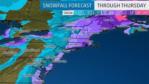
* WHAT...Heavy snow expected. Very cold wind chills possible.
Travel will be very difficult to impossible. Tree branches could
fall as well. Total snow accumulations of 8 to 12 inches, with
localized amounts up to 15 inches, are expected. Wind chills
could range from 5 below zero to 25 below zero.
* WHERE...Portions of northern Connecticut and central and
western Massachusetts.
* WHEN...For the Winter Storm Warning, until 1 AM EST Friday.
For the Wind Chill Watch, from Friday morning through Saturday
afternoon.
* ADDITIONAL DETAILS…Be prepared for significant reductions in
visibility at times. Cold wind chills as low as 25 below zero
will cause frostbite in as little as 30 minutes to exposed
skin.
PRECAUTIONARY/PREPAREDNESS ACTIONS…
A Winter Storm Warning for snow means severe winter weather
conditions are occurring. If you must travel, keep an extra
flashlight, food and water in your vehicle in case of an
emergency. The latest road conditions for the state you are
calling from can be obtained by calling 5 1 1.
A Wind Chill Watch means there is the potential for a combination
of very cold air and the wind to create dangerously low wind
chill values. Monitor the latest forecasts and warnings for
updates on this situation.
Photo above from The Weather Channel