
Occasionally we will share severe weather information consequential to public health, public safety and EMS response.

What we know:
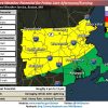
- Scattered strong to severe thunderstorms may develop after 4 pm Friday afternoon and last to at least 11 pm.
- Western and Northern Massachusetts as well as Northern CT have the best potential to see strong to severe thunderstorms.
- Cannot rule out strong storms across RI and Eastern MA during the overnight hours on Friday into early Saturday morning.
- Main threats within these storms will be damaging winds, hail, and heavy downpours which could lead to localized minor street flooding.
- An a isolated tornado cannot be ruled out.
What we don’t know:
- Will Friday morning showers and/or cloud cover limit severe weather potential
- The coverage of thunderstorms (scattered vs widespread event).
- If storms will weaken or strengthen as they move eastward into RI and Eastern MA Friday evening into Friday night.
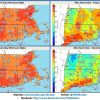
Heat issues Friday & Saturday:
- Heat and humidity will return beginning Friday and last into the weekend.
- Temperatures will warm into the low to mid 90s on both Friday and Saturday.
- Heat Indices could reach the mid 90s on Friday and low 90s on Saturday.
- Sunday will also be warm with temps in the low 90s.