ASM Responds: Winter Storm Charlotte

The Hartford Courant

By JESSE LEAVENWORTH, leavenworth@courant.com

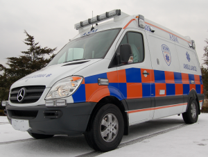
MANCHESTER — Read the whole article here…Private ambulance providers had similar difficulties. Prevented from close access to many homes, medics had to carry patients, in some cases for 100 yards or more, through thigh-deep snow, Dave Skoczulek, spokesman for Ambulance Service of Manchester and Aetna Ambulance Service, said Monday.

Ambulances mired on roadsides and stuck in deep snow banks had to be pulled out with a four-wheel drive paramedic intercept vehicle. Total calls were less than normal, Skoczulek said, “but each call was typically more severe and took much, much more effort and much longer to complete.”

Ambulance Service of Manchester Mercedes Sprinter AmbulanceAt the height of the storm, a patient with chest pains had to be taken from Johnson Memorial Hospital in Stafford to Baystate Medical Center in Springfield. A physician arranged for a plow to escort the ambulance, and there were many other stories of plows paving the way for emergency medical personnel, Skoczulek said.

Another crew in a heavy ambulance equipped with tire chains could not make it over impassable roads with a critical care patient aboard, Skoczulek said. The crew got help from Manchester police and residents, who came over with shovels and snowblowers, he said. Eventually, a backhoe from Ansaldi Construction winched the ambulance back onto a cleared road surface, Skoczulek said.

Blizzard Warnings in Effect for the Entire State

Storm TrackerPOTENTIALLY HISTORIC WINTER STORM TO IMPACT STATE TODAY AND SATURDAY

Blizzard Warnings are now in effect for the entire state until 1:00 PM Saturday Afternoon.  Blizzard Warnings are issued for sustained or gusty winds of 35 mph or more, and falling or blowing snow creating visibilities at or below ¼ mile for at least three hours which is expected tonight.

This Morning: Light snow developing across the state between 7:00 – 9:00 AM becoming moderate and steady by noon.  Temperatures holding in the upper 20’s in Northern CT and near 30 F along the coast.

This Afternoon: Snow in Northern CT with a mix in Southern CT becoming heavy at times between 1:00 – 3:00 PM with temperatures holding in the upper 20’s in Northern CT and near 30 F at the coast.

This Evening and Overnight: Blizzard conditions with any mixed precipitation changing to all snow by 7:00 PM.  Snowfall rates up to 5” per hour with zero visibilities at times and blowing and drifting snow.  Lows dropping into the low 20’s statewide with Northeast Winds gusting to 40 MPH inland and up to 60 MPH along the coast.  Moderate power outages and moderate coastal flooding expected with high tide just before midnight in Western Long Island Sound.

Saturday Morning: Heavy snow tapering to moderate snow from West to East between 7:00 – 10:00 AM.  Strong North Winds gusting to 40 MPH Inland and 50 MPH at the Coast.  Zero visibilities at times with Blizzard Conditions until 10:00 AM.

Saturday Afternoon: Moderate snow tapering off to light snow and ending by 3:00 PM.  Continued blowing and drifting of snow with Northwest winds gusting to 40 MPH at times and ground blizzard conditions at times.

Total snowfall may be historic with 12 – 24” in Western CT, 20 – 36” in Central and Eastern CT and 15 – 30” along the coast.  Isolated amounts to 40” may occur.

The Department of Emergency Services and Public Protection (DESPP) will continue to monitor the latest forecasts and will issue another update at 10:00 AM.

This product is a public service of the Department of Emergency Services and Public Protection (DESPP), and is intended for informational purposes only.  DESPP assumes no liability for the use or distribution of this product or any actions resulting from this product.