Winter Storm CO Warning

Occasionally we will share severe weather information consequential to public health, public safety and EMS response. Below is a CT DPH Press Release addressing the dangers of Carbon Monoxide Poisoning.


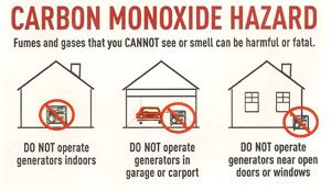
HARTFORD – With growing confidence that Connecticut will be impacted by a major winter storm on Tuesday, the Connecticut Department of Public Health (DPH) warns residents of the dangers of carbon monoxide (CO) and urges them to take steps to prevent deadly CO poisoning. In anticipation of power outages, DPH is very concerned about improper use of portable generators and other sources of heat, which could lead to CO poisoning. When power goes out many people run portable generators inside or close to the home, or use charcoal grills inside the home. Generators should be placed at least 20 feet from the house and never inside the house, on a porch, basement, garage or shed. Charcoal grills should never be used indoors.
CO is an invisible, odorless gas that can be fatal. Breathing in excessive amounts of CO can cause loss of consciousness and death. The symptoms of CO poisoning can mimic those of the flu, including headache, fatigue, dizziness, weakness, nausea, vomiting, chest pain, confusion, or loss of consciousness. People who are sleeping or unconscious can die from CO poisoning before they exhibit any symptoms. DPH warns that anyone exhibiting these symptoms should leave the house immediately and call 911 and the Connecticut Poison Control Center at 1-800-222-1222 from another location.
Improper use of portable generators have caused more than half of CO poisonings in Connecticut, according to DPH. DPH offers the following safety tips to prevent CO poisoning:

• Never use portable generators or other gasoline-powered equipment (including tools) indoors or in the garage, basement, shed or other enclosed spaces. Even if the garage or shed doors are open, CO gas can still build up to dangerous levels within minutes.
• Place portable generators at least 20-25 feet from your home. There have been instances where exhaust containing CO gas has been blown back into the house and poisoned occupants when outdoor portable generators were close to the house.
• Opening windows and doors, and operating fans is NOT sufficient to prevent buildup of CO in a home.
• Use charcoal and gas grills or camping stoves outdoors only.
• Make sure exhaust vents for your furnace and gas appliances (dyers, stoves) are free of snow. Exhaust vents blocked by snow can cause combustion gases to back up into the home.
• After a snow storm, make sure your car’s exhaust pipe is clear. A clogged exhaust pipe could lead to carbon monoxide buildup in your vehicle. Fatalities have resulted from people trying warm themselves in their car without clearing snow away from exhaust pipe due build-up of CO gas in car.
DPH developed a video, Carbon Monoxide: The Silent Killer, to help raise awareness of the dangers of CO and how to prevent poisoning. It is available online in English and Spanish by clicking on the following link: https://www.youtube.com/watch?v=Pe-8QcFJ1ME .

 

Winter Storm Stella

Occasionally we will share severe weather information consequential to public health, public safety and EMS response. Below is a warning issued by CT DESPP-EMHS.


BLIZZARD WARNINGS ISSUED FOR SOUTHERN CONNECTICUT…
WINTER STORM WARNINGS ISSUED FOR NORTHERN CONNECTICUT…

Tuesday Morning: Snow beginning between 4:00 – 6:00 AM and becoming
heavy by 9:00 AM. Blizzard conditions are expected after 9:00 AM with
extremely heavy snow (3” – 4” per hour), Northeast winds gusting to 60
MPH at times with near zero visibilities. A crippling impact on all travel is
expected. Minor coastal flooding is also possible at noontime.
Tuesday Afternoon: Blizzard conditions continue thru the afternoon with 3”
– 4” per hour snowfall rates and winds gusting to 60 MPH at times.
Conditions are expected to start to improve by 4:00 PM as the snow tapers
down to moderate levels and then to light levels by 7:00 PM.
Tuesday Evening: The light snow may continue for a few hours and end
completely by 11:00 PM. However the strong winds may continue into
Tuesday night gusting to 30 MPH at times causing a lot of blowing and
drifting of snow.
Total snowfall: of 18 – 28 inches is currently expected across Western and
Central CT with lesser amounts near the southeast coast of 10” – 15”. The
Department of Emergency Services and Public Protection Division of
Emergency Services and Public Protection will continue to closely monitor
this dangerous storm. Another update will be sent out this afternoon at 2:00
PM once the new model runs are in.

Winter Storm Tracking

Occasionally we will share severe weather information consequential to public health, public safety and EMS response. Below is a warning issued by CT DESPP-EMHS.


WINTER STORM WARNINGS ARE NOW IN EFFECT FOR THE ENTIRE STATE…

BLIZZARD WARNINGS HAVE BEEN ISSUED FOR LONG ISLAND…

HEAVY SNOWSTORM UNDERWAY ACROSS SOUTHERN NEW ENGLAND…

STATUS OF THE STATE EMERGENCY OPERATIONS CENTER – ACTIVATED

At 7:45 AM: Moderate to heavy snow was falling across the state. Roads are quickly

becoming snow covered with lowering visibilities. Temperatures are currently in the

upper 20’s and low 30’s across the state. Northeast winds are sustained at 10 – 15

MPH, gusting to 30 MPH at times along the coast.

Rest of This Morning: Snow, heavy at times with near blizzard conditions and

snowfall rates up to 3” per hour. A major impact on travel is expected with several

inches of snow on most roads. Very slick driving conditions are expected with low

visibilities down to ¼ mile at times. Northeast winds will increase to 15 – 25 MPH,

gusting to 35 MPH at times along the coast. Temperatures will continue to fall into

the upper 20’s by noon.

This Afternoon: Snow beginning to taper off during the early afternoon and ending by

5:00 PM. Blowing and drifting of the snow is expected with north winds gusting to 20

– 35 MPH. The impact on the afternoon rush hour is expected to be at the high end of

moderate with some snow cover remaining on most roads and temperatures in the

upper 20’s.

Total accumulations are currently forecast to range from 12″ – 16″ statewide with

isolated higher amounts especially in eastern CT. The snow is expected to be dryer in

northern and central CT and somewhat wetter along the southeast coast. No icing or

significant coastal flooding is expected with this storm. The overall impact of this

event is expected to be major.

The next update will be sent out by the Department of Emergency Services and Public

Protection Division of Emergency Management and Homeland Security at 10:00 AM.


Winter Storm “Chris” Update

Occasionally we will share severe weather information consequential to public health, public safety and EMS response. Below is a warning issued by CT DESPP-EMHS.

WINTER STORM WARNINGS ISSUED FOR THE ENTIRE STATE…
HEAVY SNOWSTORM EXPECTED ON THURSDAY…
STATUS OF THE STATE EMERGENCY OPERATIONS CENTER – MONITORING

As colder air moves into our area tonight a low pressure system is forecast to form along the cold front in Virginia. This low is forecast to move quickly to the Northeast as the storm intensifies Thursday morning off the Del-Mar-Va Peninsula. The storm is forecast to generate a large area of moderate to heavy snow which will impact southern and central New England on Thursday. The following forecast is based on a blend of the GFS and NAM models and currently has a good confidence level:

Tonight: Becoming cloudy with temperatures dropping into the mid 30’s. Snow is expected to move into the state between 5:00 – 7:00 AM Thursday morning. The snow is expected to become moderate within 2 hours of starting. Temperatures continuing to fall into the low 30’s by daybreak.

Thursday Morning Rush Hour: Moderate snow becoming heavy at times with 2+ inches of snow on roads and snowfall rates of 1″ – 2″ inches per hour by 9:00 AM. The impact on the morning rush hour is expected to start as moderate and become major by the end of the rush hour. Very slick driving conditions are expected with low visibilities down to (1/4) mile at times. The snow is expected to continue heavy at times thru the morning with temperatures continuing to fall into the upper 20’s by noon.

Thursday Afternoon: Snow tapering off during the early afternoon and ending by 4:00 PM. Some blowing and drifting of the snow is expected with north winds increasing to 20 – 30 MPH. The impact on the afternoon rush hour is expected to be moderate with some snow cover remaining on most roads and temperatures in the upper 20’s.

Total accumulations are currently forecast to range from 8″ – 14″ statewide with isolated higher amounts. The snow is expected to be dryer in northern and central CT and somewhat wetter in southern CT. No icing or significant coastal flooding is expected with this storm. The overall impact of this event is expected to be moderate to major.

Updated 2-7-17 at 430PM

External Winter Storm Update from DESPP: January 2016

DESPP Facts and Figures Jan 2016 StormOccasionally we will share severe weather information consequential to public health, public safety and EMS response.

SOURCE: CT DESPP-EMHS

Click here for full DESPP Report and Map: DESPP External Winter Storm Update 1-22-16 at 115 PM

WINTER STORM WATCHES ISSUED FOR SOUTHERN CT…

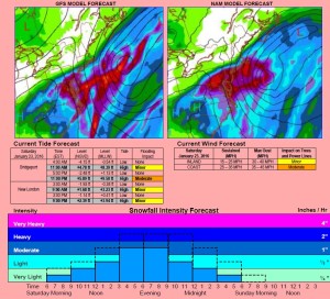
LATEST COMPUTER MODELS TRENDING A LITTLE NORTH AGAIN WITH A VERY SHARP NORTHERN EDGE TO THE SNOWFALL OVER CONNECTICUT…

The last model runs of the GFS, NAM and EURO model forecasts are in good agreement on the track however they are still not in good agreement on the amount of snowfall for Connecticut.  The NAM has more than twice the snowfall of either the EURO or GFS.  All three models are still showing a very narrow snowfall cutoff across Connecticut meaning that any slight change in the track will result in a very significant change in snowfall. 

The following forecast is based on a blend of all three models:  Light snow is forecast to spread from south to north across the state tomorrow morning between 6:00 – 10:00 AM.  The snow is forecast light to moderate in northern CT and moderate to heavy at times along the coast by late Saturday afternoon.  The snow is forecast to continue Saturday evening and begin tapering down around midnight.  The snow is forecast to end before dawn on Sunday.  The snow is forecast to be fairly dry and powdery.  The snow will be accompanied by strong Northeast winds gusting to 35 – 45 MPH at times.  Cold temperatures in the upper 20’s are also expected. 

Total snowfall predictions at this time range from 2” – 3” in northern CT, 3” – 6” in central CT and 6” – 10” along the coast.  Note: Very heavy snow with blizzard conditions are expected just to our south over Long Island and New York City.

Current Forecasted Impacts:

Travel Impact:   Saturday AM                  Saturday PM                 Sunday AM                   

                                 Minor                              Moderate                       Minor

Coastal Flooding:   Saturday AM                  Saturday PM                 Sunday AM

                                  Minor                              Moderate                       Minor

Overall Impact:   Minor to Moderate

Forecast Confidence:   Good Confidence for Track / Fair Confidence for Snowfall